
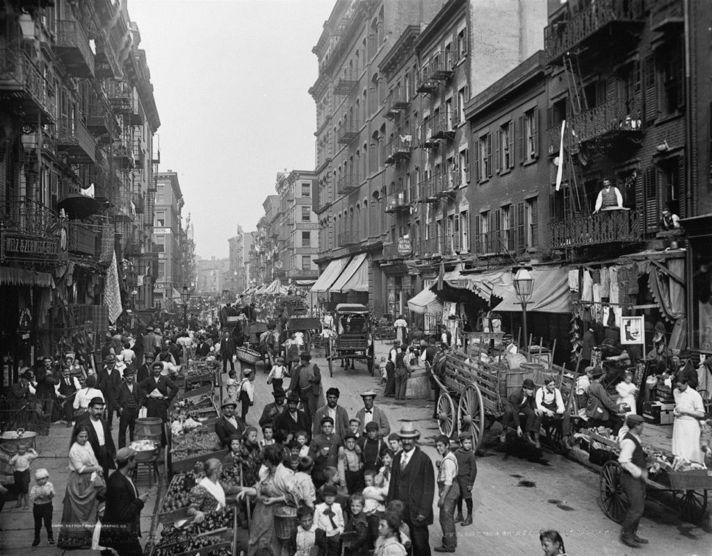
In the 1900s, American cities became centers of industry with an overwhelming demand for housing due to immigration. The result was a new housing form: the tenement – that created an unhealthy living environment, and instant slum without minimum standards for light and air, or even running water, thwarting any attempt at personal hygiene.
Migration to America was an attempt to attain greater freedoms – religious, speech – as well as protections from excessive regulation and governance. Although a retrospective analysis of the Puritan settlements shows that not to be the case. As the ability to acquire land in the European nations, was greatly limited as it was either passed through individual families or retained by either local lord or the Crown, the acquisition of land created another incentive to come to America together with freedoms of speech, religious practices and mobility. Large-scale manufacturing required a tremendous number of workers, each industry recruited them from both the American countryside where small farms were failing, and encouraged the immigration of laborers from distant lands across the seas.
While tenements were a lucrative investment for realtors and builders. This approach to housing left the workers without the possibility of rudimentary household cleanliness, an accommodated filth and disease over human living needs. The blighting of the city soon became insufferable. Progressive movements sought to alleviate the social injustices of time. Meanwhile, industrial technology provided steel to frame higher buildings, eliminating height restrictions associated with masonry construction. The elevator provided for vertical transport in the new architectural form now known as the “skyscraper” As cities began to fill with skyscrapers in the early 20th century, planners now turned their interest from the layout and footprint of neighborhoods at the street level to the volume of buildings as they rose toward the sky. In 1916, The New York City zoning resolution was a measure adopted primarily to stop massive buildings such as the Equitable Building from preventing light and air from reaching the streets below. It also established height and setback controls and designated residential districts that resulted in improved living conditions. New York wasn’t the first place to divide the city up based on who was doing what, where. After the Second World War, land development became a fragmented process driven by economies of scale. Technical specialists controlled the various phases of the development process — engineers designed the streets and sidewalks, the fire department controlled the relationship between buildings, streets and water, the parks department managed parks, and planners administered zoning codes that determined minimum lot sizes and what land uses were allowed in each zone. Attorneys codified all of the rules that dictated what could or could not be done. There was no collaboration between each discipline, but rather a bifurcated approach to urban design.
The built environment reflected whatever could be developed after the specialists had their say — usually a hodgepodge of unintended consequences rather than the product of a coherent vision. In the early 20th century, American cities look much different than they do today. In heavily urbanized areas, houses, shops and factories could also be found on the same block, and many city dwellers spent their time in overcrowded buildings that suffer from poor natural light.
The planning of new settlements in North America has occurred in sporadic fashion from since the birth of this country. For example, in 1699, Williamsburg was laid out under the most detailed piece of town-planning legislation adopted in the English colonies up to that point. Williamsburg reflected what is referred to as “axial planning,” meaning formal but not pompous.
While the Columbian Exposition of 1893 is considered the originating event for modern planning; It is also thought, the modern era of planning for growth and development began in 1900, when several papers dealing with the beautification of government buildings were presented at an annual meeting of the American Institute of Architects in Washington, D.C.
Early on, this planning process was referred to as the “City Beautiful Movement.” This movement established two components of a comprehensive planning process that remain to this day. First, the reliance on a professional consultant in the planning process, secondly the creation of a planning commissions to oversee that process.
America’s 1785 Land Ordinance divided federally owned lands west of the Ohio River into a neat grid of townships 6 square miles in size. Each containing 36 square-mile parcels This approach fostered the Jeffersonian vision for agrarian, land-owning society if you drive across – or fly over – the Midwest today, its effects still linger in all those perfectly perpendicular roads and square farms. Frank Lloyd Wright took the geometry of this rural grid even further in his vision for a utopia with each family living on an acre of its own. That level of density would have essentially spread suburbia over the entire country.
The early suburbs are in fact.” Urban sprawl .”” They were directly connected to urban centers by trolley lines, the turn-of-the-century mass transit. “The really big constraint of land use regulation was the inability of people to get very far within cities,” says William Fischel, a Dartmouth College professor who studies zoning. That changed with public transportation. In his opinion – “Once you got the street car you could separate residents from jobs,”
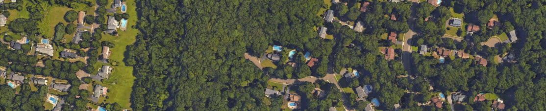
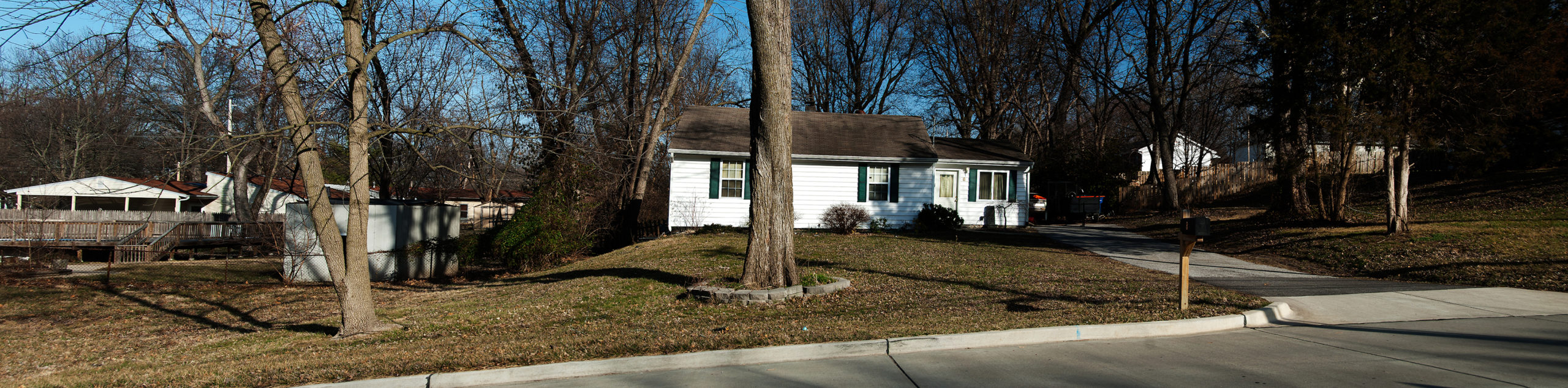
Today they are considered better alternative to suburban living. And have become the model for “new urbanism”. Suburbs of the 1950s and later have very distinct causes. Federal policies designed to create housing opportunity for veterans, may be considered one of the primary triggers for suburban sprawl. The economic approach now made a mortgage more affordable. A mortgage payment for a house was becoming a viable alternative to paying monthly rent. Over 11 million homes were constructed due to discounted loan programs from the FHA or Veterans Administration. Eisenhower’s efforts to create a highway system as part of national defense – the interstate (a 41,000 mile highway. Federal subsidies for local highways and roads literally paved the way for suburban commuters. The automobile now replaced the trolley lines. Henry Ford’s approach to the mass production of the automobile was now applied to home construction. Kunstler states in his book, Suburban Nation… “The CEO’s desire for a shorter commute, coupled with suburbia’s lower tax burden, led to the development of the business Park, completing the migration of each of life’s components into the suburbs. As commuting patterns became predominantly suburb to suburb, many center cities became “expendable” as industrial, business and commercial centers. “Sprawl started to rise in the mid-1920s—indicated by a drop in average street node scores. The trend suggests that developers started to copy the early cul-de-sac planning that occurred in the likes of Radburn, New Jersey, in 1928. Radburn is an unincorporated community located within Fair Lawn in Bergen County, New Jersey, United States.
Radburn was founded in 1929 as “a town for the motor age”. Its planners, Clarence Stein and Henry Wright, and its landscape architect Marjorie Sewell claimed to incorporate modern planning
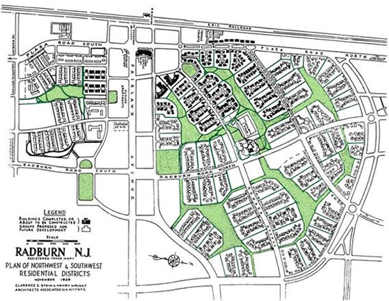
principles, which were then being introduced into England’s Garden Cities, following ideas advocated by urban planners Ebenezer Howard, Sir Patrick Geddes and Clarence Perry. Perry’s Neighborhood unit concept was well-formulated by the time Radburn was planned,